Paddling
-
Audubon Acres
Located east of Chattanooga off of I-75, this beautiful sanctuary serves as the headquarters of the Chattanooga Audubon Society and provides a peaceful retreat in the middle of a vast suburban shopping and residential district.
The 132-acre Elise Chapin Wildlife Sanctuary at Audubon Acres contains a rich diversity of plant and animal life. The property includes access to the South Chickamauga Creek, 5 miles of trails, a Visitor's Center, gift shop, a timeline museum tracing the human habitation of the property, and structures that are significant to the area’s Native American History. Field trips and group tours are available.Hiking | Running
Discover 5 miles of trails on 130 acres. A swinging bridge carries visitors over South Chickamauga Creek to explore forest, riparian, wetland, meadow, and hilltop habitats.
Paddling
Access to South Chickamauga Creek is available seasonally for paddling, swimming, and floating. Picnic tables and a fire ring make a great setting for group gatherings.Directions
Difficulty
Hiking
Running
Paddling
Guides
Hours and Cost
Open Daily: Monday-Saturday 9 a.m.-5 p.m., Sunday 1 p.m.-5 p.m.
Cost: Adults $6, Seniors $5
Students $5 (with student ID)
Children (5-12) $3, under 5 Free
Pet Friendly
No.
Contact
Audubon Acres 900 North Sanctuary Rd. Chattanooga, TN 37421 423-892-1499
-
Booker T. Washington State Park
The 353-acre Booker T. Washington State Park is the closest Tennessee State Park to downtown Chattanooga. Located on a hilly peninsula that juts into Chickamauga Lake, the scenic park is a perfect location for family outings. The park offers a swimming pool, pavilion picnic areas, a playground, multiple fishing piers, a boat ramp and 6-miles of hiking and biking trails.
Booker T’s 6-mile singletrack trail is a gnarly, twisty, rooty, challenging ride for intermediate level mountain bikers. Riders attempting the trail should have the skills to safely negotiate steep climbs, roots, and rocks. Hikers and trail runners can also use the trail and enjoy an off-road experience close to town.Fish are abundant in Lake Chickamauga and Booker T offers one of the best fishing areas near Chattanooga. Primary species of sport fish include white crappie, bluegill, white bass, channel and blue catfish, largemouth bass, and sauger. Anglers can use one of the multiple fishing piers at the park or utilize the motorized boat ramp to get out on the lake.Directions
Difficulty
Hiking
Running
Biking
Paddling
Guides
Hours and Cost
Open Daily: Sunrise to Sunset
Cost: Free
Pet Friendly
Yes, on a leash
Contact
Booker T. Washington State Park 5801 Champion Rd. Chattanooga, TN 37416 423-894-4955
-
Cartecay River
Situated on the edge of the Cohutta Wilderness in the Chattahoochee-Oconee National Forest, the Cartecay River is a gently rolling mountain stream that becomes a fun, Class II+ run for two and a half miles outside of Ellijay, Georgia.
A step up in from the Hiwassee River for beginner paddlers, the Cartecay’s signature rapids require a little more technical and maneuvering skills.The river levels are subject to rainfall and at high water, some rapids increase in difficulty to Class III. Conversely, in drought periods, the river can become very low and scrapey.
NOTE
Most of the land along the banks of the Cartecay is privately owned. Plan accordingly, as there are no places to take out for bathroom breaks or other necessities.
PARKING
There is very limited parking along the Cartecay, so using parking and shuttle service from a commercial outfitter is highly recommended.Directions
Difficulty
Kayaking
Hours and Cost
Open Daily: Sunrise to Sunset
Cost: Free. Guiding services vary
Pet Friendly
No
-
Chattooga River
The Chattooga Wild and Scenic River flows through a protected wilderness corridor for 59 miles along the Georgia/South Carolina border in the southern Appalachian Mountains. The river is legendary for its intense rapids and rugged scenery. Paddling on the Chattooga, no matter which section, should be approached with the utmost respect due to being in a wilderness setting where cell phone service is nonexistent and help is generally a long hike away.Section 2
Most of this section is a scenic float trip, with one significant class II+ rapid: Big Shoals, which should be scouted before running. Though the river runs next to the road in this section, access to help or amenities is still very limited.
Section 3
This section contains mostly Class II-III rapids, generally spaced from a half mile to over a mile apart. The last rapid, Bull Sluice (Class IV+) can be avoided by taking out at the top.
Section 4
The Chattooga’s infamous Five Falls (Entrance, Corkscrew, Crack in the Rock, Jawbone, Soc ’em Dog) finish off this fast and intense whitewater run, which is only for the most experienced paddlers.Directions
Difficulty
Paddling
Hours and Cost
Open Daily: Sunrise to Sunset
Cost: Free. Guiding services vary.
Pet Friendly
Yes, on a leash along the bank and in the Francis Marion and Sumter National Forest.
Contact
Sumter National Forest—Andrew Pickens Ranger District
112 Andrew Pickens Cir.
Mountain Rest, SC 29664
864-638-9568
-
Chester Frost State Park
Located 25 minutes from Chattanooga, Chester Frost County Park contains a power boat launch, boat docks and ramps, a swimming beach, fishing piers, group picnic facilities, an indoor pavilion, and a developed campground for RV, tent, and group camping on the shores of Chickamauga Lake. The Park is operated by Hamilton County and the facility hosts fishing tournaments, competitive events, and the annual Hamilton County Fair each September.There are 188 RV campsites with water and electrical hookups and a limited number that can accommodate RV’s up to 65ft. There is one centralized dumping station and several bathhouses. There are only 82 sites available during the winter months and tent camping is also available.
Located on Chickamauga Lake, the waters around Chester Frost host abundant sport fish like white crappie, bluegill, white bass, channel and blue catfish, largemouth bass, and sauger.
Chester Frost’s location also allows easy access by paddle craft to adjacent sloughs and marshes for anglers and wildlife watchers.Directions
Difficulty
Paddling
Guides
Hours and Cost
Open Daily
Cost: Varies based on campsite amenities and length of stay.
Pet Friendly
Yes, on a leash. However, pets not allowed on the beach.
Contact
Hamilton County Parks and Recreation
2277 N. Gold Point Circle North
Hixson, TN 37343
(423) 843-0146
-
Chilhowee Recreation Area
Located in the Cherokee National Forest, the Chilhowee Recreation Area is an excellent hub for hiking, mountain biking, fishing, camping and wildlife viewing. The 7-acre McKamy Lake offers a swimming area with a sandy beach, fishing from the bank and flatwater paddling opportunities. There are 25 miles of hiking and biking trails, including the easy 1.5-mile trail to Benton Falls. Wildlife is abundant in the recreation area and scenic overlooks on the drive up the mountain provide great sunset views of Parksville lake (pictured), so have your camera ready and tread lightly.Chilhowee Campground offers more than 70 campsites, electric hookups, RV sites, tent only sites, and multiple bathhouses with warm showers. The Campground is open from early April to late October, with an overflow area and day use area open year-round. The recreation area is in close proximity to Parksville Lake (Ocoee Lake), the Ocoee River, Big Frog Wilderness, the Tanasi trail system at the Ocoee Whitewater Center, and the Hiwassee River.
Reservations can be made for Chilhowee Group Camp and individual sites at Loops A, B, E, and F. To make a reservation, please call 1-877-444-6777 or online at www.recreation.gov.
Directions
Difficulty
Hiking
Running
Biking
Paddling
Hours and Cost
Open Daily: Early April-Late October, Sunrise to Sunset
Cost: Day use, $3/vehicle. Camping varies based on site amenities and length of stay.
Pet Friendly
Yes, on a leash. However, pets not allowed on the beach.
Contact
Ocoee Ranger District 3171 Highway 64 Benton, TN 37307 423-338-330
-
DeSoto State Park
Desoto State Park is nestled atop Lookout Mountain in Northeast Alabama. The 3,502-acre Alabama State Park features waterfalls, abundant spring wildflowers and stunning, historic facilities that were constructed by the Civilian Conservation Corps.
DeSoto’s improved campground has 94 full hookup tent and RV sites. For the more adventurous, there are also primitive camping sites for tents as well as two backcountry campsites with shelters.Other amenities include a restaurant, meeting rooms, pavilions, picnic area with playground, Olympic-size swimming pool (seasonal), an ADA accessible boardwalk trail, a nature center featuring interpretive programs and live animals, a Civilian Conservation Corps museum, and more than 30 miles of hiking trails and 11+ miles of mountain biking trails that vary in terrain from easy to strenuous.
Trail maps can be found at the Lodge, Country Store, & Nature Center. All mountain bike trails are marked silver on the trails and by diamonds on the trail map.
Desoto Falls is located 7 miles North from Desoto State Park in Mentone Alabama. It's definitely worth the drive to see in person. Paddling options are available upstream of the falls on the Little River.Directions
Difficulty
Hiking
Running
Biking
Paddling
Hours and Cost
Open Daily
Cost: Varies based on campsite amenities and length of stay.
Pet Friendly
Yes, on a leash
Contact
DeSoto State Park 7104 DeSoto Parkway NE Fort Payne, AL 35967 256-845-5380
-
Fort Mountain State Park
Located near the Cohutta Wilderness in the Chattahoochee-Oconee National Forest, Fort Mountain State Park is a 3,712-acre mountain getaway in North Georgia.
Hikers, mountain bikers and horseback riders will find some of the most beautiful trails in Georgia, winding through hardwood forest and blueberry thickets, crossing streams and circling a 17-acre lake. Hikers can explore a stone fire tower built by the Civilian Conservation Corps and an ancient rock wall that stands on the highest point of the mountain.During summer, visitors can cool off by swimming at the lakeside beach or renting a paddle craft to play on the lake. The Park's stables offer guided horseback rides and stall rental throughout the year. Park guests may stay overnight in fully equipped cottages, at the campground which has 80 tent, trailer or RV campsites with hookups and bathhouse facilities, walk-in sites, a group shelter or pioneer campsites or at one of the 4 backcountry campsites.Directions
Difficulty
Hiking
Running
Biking
Paddling
Guides
Hours and Cost
Open Daily: Sunrise to Sunset
Cost: $5 day use parking. Camping varies based on site amenities and length of stay.
Pet Friendly
Yes, on a leash
Contact
Fort Mountain State Park 181 Fort Mountain Park Rd. Chatsworth, GA 30705 706-422-1932
-
Harrison Bay State Park
Designated Tennessee’s first state park in 1937, Harrison Bay State Park is a 1,200-acre park located off Hwy 58, just 25 minutes from Chattanooga. This beautiful wooded park is a haven for campers, golfers, boaters, and anglers, as well as picnickers and other day-use visitors. With almost 40 miles of shoreline on Chickamauga Lake, it has one of the most complete marina facilities available on any of the TVA lakes and all types of boats and watercraft are allowed at the park.The park has a 4.5-mile loop trail that is perfect for trail running, family hikes or as an introduction to singletrack mountain biking. The twisty singletrack runs around a peninsula offering views of Chickamauga Lake. Hybrid and kids bikes can readily handle the terrain on this trail.
There are 128 RV campsites with water and electrical hookups and a limited number that can accommodate RV’s up to 65 ft. There is one centralized dumping station. Bathhouses are located in each of the 4 camping areas as well as a playground.
Rusty's Kayak and Paddleboards offers rentals throughout the year near the park entrance. There are fishing piers, a swimming pool, self-guided star-walk and a wildlife exhibit at the park. And the scenic Bear Trace Golf Course is nearby.Directions
Difficulty
Hiking
Running
Biking
Paddling
Guides
Hours and Cost
Open Daily: Sunrise to Sunset
Cost: Free for day use. Camping rates vary based on site amenities and length of stay.
Pet Friendly
Yes, on a leash
-
Hiwassee River
The Hiwassee River Blueway offers 55 miles of adventure in Southeast Tennessee. Extending from the Appalachia Dam near the border of North Carolina to the Tennessee River at Blythe's Ferry in Birchwood, the wide river is well known for its water-based recreational opportunities including tubing, kayaking, rafting, and fishing.The upper section of the Hiwassee River is the most popular section of the river, offering an easy to moderate whitewater experience on Class I and II rapids, with the occasional Class III. This section winds through the mountains of the Cherokee National Forest and is designated as a Tennessee State Scenic River. There are a number of outfitters near the river that offer raft, funyak and tube rentals between Memorial Day and Labor Day each year. The middle section consists of swift flatwater between the Highway 411 bridge and Charleston, offering slow, peaceful floats and fishing for trout, bass, bluegill, and crappie. During most summers, striped bass make their way up this stretch of the river, as well. Motorboats can generally navigate to the Patty Bridge access area. The lower section is slow-moving flatwater between North Mouse Creek to Blythe Ferry boat ramp near the Hiwassee Wildlife Refuge and the Tennessee River. All types of boats can navigate this stretch of the waterway, moving between many inlets and islands. Fishing is abundant in the main channel, inlets, and creeks along the way. Agriculture and industry line of the banks of this section of the river, with a few marinas to provide food, drinks, and fuel. CAUTION: The Hiwassee River water release schedule is controlled by Tennessee Valley Authority's Apalachia Dam. Water release schedules can change suddenly and without notice due to changes in weather conditions and power system requirements. The depth and swiftness of the river can change rapidly in the upper section of the river. Your safety depends on obeying all posted safety regulations and warnings. Two generators are required for adequate water levels on the upper section for recreational boaters. TVA releases two generators on weekends Memorial Day through Labor Day. This release typically begins at 11 a.m. and boaters can generally get on the river by NOON below the Appalachia Powerhouse. Be sure to double-check TVA - Apalachia Water Release Schedule before you go.Difficulty
Kayaking
Tubing
Hours and Cost
Open Daily: Sunrise to Sunset
Cost: Free. Guiding services vary
Pet Friendly
No.
Contact
Cherokee National Forest—Ocoee Ranger District 3171 Highway 64
Benton, TN 37307
423-338-3300
-
Hiwassee Wildlife Refuge
The Hiwassee Wildlife Refuge is located on 6,000 acres of land encircling the confluence of the Tennessee and Hiwassee Rivers about one hour north of Chattanooga near the town of Birchwood.
In the summer months, the public can access all lands and waters within the refuge to observe resident and migrating birds and seasonal wildflower blooms, including great swaths of water hyacinths in Hiwassee Island’s inlets. During the winter, migrating waterfowl, including 50,000 Sandhill Cranes and some endangered Whooping Cranes, stop over at the refuge on their way south.The Hiwassee Refuge is also steeped in Native American history, lying near the center of Cherokee Nation’s ancestral lands, which once stretched into Kentucky, Tennessee, Alabama, Georgia, South Carolina, North Carolina, Virginia and West Virginia. Blythe Ferry, one of the debarkation points for the Cherokee Forced Removal (Trail of Tears), is now home to the Cherokee Removal Memorial Park.
Hunting
The Tennessee and Hiwassee River watersheds provide hunting opportunities for a variety of big and small game, including waterfowl and Sandhill Cranes. Drawings are held each October for seasonal blind/spots, located to the north and east of Chattanooga. Waterfowl hunting is permitted Thursday – Sunday, and the first and last day of duck season.
Waterfowl hunting permits and WMA seasons are managed by the Tennessee Wildlife Resources Agency.Directions
Difficulty
Hiking
Paddling
Guides
Hours and Cost
Open Daily: Sunrise to Sunset
Cost: Free
Pet Friendly
Yes, on a leash
Contact
Tennessee Wildlife Resources Agency Region III
464 Industrial Blvd.
Crossville, TN 38555
931-484-9571
1-800-262-6704
-
Lookout Creek
Lookout Creek meanders below the western face of Lookout Mountain, spilling into the Tennessee River near the toe of Moccasin Bend. It is a part of the Tennessee River Blueway system.
Though sections of the creek are navigable from Trenton, Georgia to Chattanooga, the most accessible part is a 2.5-mile section between the Tennessee River and Reflection Riding Arboretum and Nature Center.Paddlers can access the creek via launches on the Tennessee River, Browns Ferry Marina, or launch at the Nature Center (fees apply).
WARNING
Water levels on Lookout Creek can fluctuate due to discharge from Chickamauga Dam on the Tennessee River. Check Tennessee Valley Authority lake levels and release schedule before you go.Directions
Difficulty
Kayaking and Canoeing
SUP
Hours and Cost
Open Daily: Sunrise to Sunset
Cost: Free
Pet Friendly
Yes, on a leash
Contact
Reflection Riding Arboretum and Nature Center
400 Garden Rd.
Chattanooga, TN 37419
423-821-1160
-
Maclellan Island
The Maclellan Island Sanctuary is located in the middle of downtown Chattanooga on the Tennessee River.
Owned and managed by the Chattanooga Audubon Society, the sanctuary contains a very large Great Blue Heron rookery, numerous waterfowl nesting sites and also serves as a home to muskrat, river otters, and the occasional white-tailed deer.The public can access the island via a power boat dock on the southwest side or a canoe and kayak launch on the northeast side. The island contains a system of hiking trails, a group campground and is a designated campsite for the Tennessee River Blueway paddling trail. Day and overnight usage fees apply.
The best launch for canoes, kayaks and SUP’s in downtown Chattanooga is located on the north shore of the Tennessee River in Coolidge Park, under the John Ross (Market St.) Bridge.Difficulty
Paddling
Pet Friendly
No.
Contact
900 North Sanctuary Rd.
Chattanooga, TN 37421
423-892-1499
423-892-3690
-
Nantahala River
The Nantahala River runs through the Western North Carolina mountains in a shaded gorge, giving it the distinction of being the coldest whitewater stream in the Southeast. Averaging only 4 hours of direct sunlight per day, the water temperature averages a bone-chilling 45 degrees.The classic class II-III run begins from the Nantahala River Launch Site, near Beechertown, N.C., and ends 8 miles downriver at Nantahala Falls. A shorter run starts 3 miles downstream at Ferebee Memorial Picnic Area.
The river is pushy, rocky, and Nantahala Falls is a challenge for all developing paddlers. It is highly recommended to do your first run with an experienced guide.
NOTE
The Nantahala is dam controlled and generally runs 7 days per week, except for November. In drought years, releases can be cut back more. Check Duke Energy Nantahala Dam Release Info before going, or call 866-332-5253.Directions
Difficulty
Paddling
Hours and Cost
Open Daily: Sunrise to Sunset
Cost: $1 per person for a daily pass and $5 per person for an annual pass. Guiding services vary.
Pet Friendly
Yes, on a leash along the banks and in the Nantahala National Forest.
Contact
Nantahala National Forest 90 Sloan Rd. Franklin, NC 28734 828-524-6441 Email: nantahalard@fs.fed.us
-
Nickajack Lake
Nickajack Lake is the reservoir created by Tennessee Valley Authority's (TVA) Nickajack Dam. It extends 46 miles upstream from Nickajack Dam to Chickamauga Dam, passing through the heart of downtown Chattanooga and offering spectacular views Tennessee River Gorge.
Boat ramps and fishing berms are located on both sides of the river below the dam, and a concrete fishing pier with footbridges and a wheelchair ramp is available. TVA camping and picnicking facilities are also available.
The river is prime habitat for small and largemouth bass, striped bass, white bass, panfish, and catfish. When the river leaves the gorge and opens up into Nickajack Lake, anglers can access islands, sloughs and the outflow of dozens of underground springs and caverns, perfect hiding places for the perfect catch.Nickajack Cave Wildlife Refuge was once used by Native Americans and Civil War soldiers. It now offers a special wildlife viewing opportunity each evening at dusk between late April and early October when thousands of endangered gray bats emerge for their nightly feeding.
Two boat launches on either end of the cave’s inlet allow for easy access by paddle craft to the mouth of the cave, which provides the best vantage point for viewing the bats. NOTE: Paddlers should be equipped with a white stern light or headlamp, as they will be paddling back to the launch after dark.
The Maple View Public Use Recreation Area has a swimming area, picnic tables and a trail with an observation deck that leads to the mouth of the cave, giving those without a watercraft access to view the bats.Difficulty
Paddling
Hours and Cost
Open Daily: Sunrise to Sunset
Cost: Free
Pet Friendly
Yes, on a leash
Contact
400 West Summit Hill Drive
Knoxville TN 37902
(865) 632-2101
1-800-882-5263
tvainfo@tva.com
-
North Chickamauga Creek Greenway
The Greenway Farm Park is a 180-acre city park along North Chickamauga Creek in Hixson, TN, located off Hamill Road approximately 1 mile east of Highway 153. The 220 total acres managed by the City of Chattanooga as the North Chickamauga Creek Greenway features 6 miles of walking, running, hiking, and biking trails, and 2 canoe access points along a 2.5 mile stretch of North Chickamauga Creek. Facilities at the Greenway Farm include the farmhouse with space available for rent for events, an off-leash dog park, and bathroom facilities.
Outdoor Chattanooga and the non-profit North Chickamauga Creek Conservancy maintain offices at the Farm. The Outdoor Chattanooga Barn houses the City of Chattanooga’s fleet of canoes, whitewater and sea kayaks, and serves as a hub for their outdoor recreation programming.Running, Hiking, Biking
The main Greenway Trail along North Chickamauga Creek is a mixed-use trail of asphalt or crushed rock surface. There are spur trails that include mowed grass trails and single-track dirt trails. The Boy Scout Trail within TVA’s Big Ridge Small Wild Area is restricted to foot traffic only. The Small Wild Area is a sensitive preserve of plant and animal habitats and includes a population of the federally threatened wildflower Scutellaria montana, or large-flowered skullcap. The Boy Scout Trail is a steep trek up the side of Big Ridge that makes it a challenging 1.25-mile loop.
Paddling
North Chickamauga Creek begins on the Cumberland Plateau, spilling Class IV/V whitewater down the ridge until it flattens in the Tennessee River valley. When the creek reaches the community of Hixson, it becomes a perfect creek for families and beginners in any type of paddle craft to enjoy an afternoon paddle along the 2.5-mile stretch that bends around a peninsula at the City of Chattanooga’s Greenway Farm Park. There are two public canoe/kayak launch points at the park for convenience. Creek levels can fluctuate due to water releases from TVA’s Chickamauga Dam on the Tennessee River. Be aware of release schedules before launching.Difficulty
Hiking
Running
Biking
Paddling
Hours and Cost
Open Daily: Sunrise to Sunset
Cost: Free
Pet Friendly
Yes. Fenced dog park for off leash play Dogs must be on leash every where else in park
Contact
City of Chattanooga Parks 423-425-6311
-
Ocoee River
The Ocoee is Southeast Tennessee's iconic whitewater river and provides recreational opportunities for paddlers of all skill levels. The river is dam controlled at 3 levels creating 3 sections - the upper, middle and lower, each offering very different paddling options. The Ocoee begins as a Class III-IV whitewater river, providing an exhilarating adrenaline rush for rafters and skilled kayakers. As it travels toward Parksville lake, the river calms and becomes the perfect venue for lazy afternoon flatwater paddling or tubing trips. There are 22 commercial rafting outfitters serving an average of 250,000 annual visitors brave enough to take on the Class III-IV rapids of the middle and upper sections of the Ocoee. Are you one of them?Upper Ocoee
The Upper Ocoee River provides 5 miles of challenging whitewater in a spectacular mountain setting. Considered by many to be the birthplace of freestyle kayaking, the Ocoee was world famous before it hosted the 1996 Olympics’ whitewater events. The Upper Ocoee includes the Class IV Olympic course, and should only be attempted by the most experienced paddlers or with a commercial rafting outfitter.
Middle Ocoee
The Middle Ocoee is the most popular section of the river and run of choice for thousands of rafters and kayakers each year. This section boasts 5 miles of nearly continuous Class III-IV whitewater including several surf-worthy hydraulics and kayak play spots like Washing Machine, Double Suck, Flipper and Hell’s Hole.
Lower Ocoee
After the whitewater spills into Parksville Lake, the river calms, rolling quietly through the pasturelands of the Appalachian foothills. Several Ocoee rafting outfitters provide tubes for flatwater tubing trips on this section of the river. For those with their own tubes, canoes, kayaks or paddle boards, there are several options to take out below the Sugarloaf Recreation Area (Ocoee Dam #1) at public and private launches and campgrounds.
NOTE: The Ocoee River is dam controlled. Be sure to check the Tennessee Valley Authority’s Ocoee Dam #1 recreational release schedule before scheduling your lower Ocoee tubing trip. No release = no water.Difficulty
Upper and Middle Ocoee
Lower Ocoee
Hours and Cost
Open Daily: Sunrise to Sunset
Cost: Free for individual/private boaters. Guiding services vary-contact companies directly for costs.
Pet Friendly
Yes, on leash
Contact
Cherokee National Forest—Ocoee Ranger District
3171 Highway 64
Benton, TN 37307
423-338-3300
-
John A. Patten Island
John A. Patten Island is a primitive, wooded retreat located in Harrison Bay State Park. The 100-acre island and its sister islands are all that remain of the town of Harrison, which was flooded by the Tennessee Valley Authority (TVA) when Chickamauga Lake was formed in 1940.In addition to seeing a wide range of wildlife on the island, including deer, turkey, waterfowl, eagle and osprey, adventurers can also see remnants of the old town, especially when road beds and house foundations are exposed by low lake levels in winter.
The island can be accessed by canoe, kayak, and SUP from launches at Harrison Bay State Park to the east and north.
WARNING: There are no trails on John A. Patten Island, so a compass is highly recommended.Difficulty
Paddling
Hours and Cost
Open Daily: Sunrise to Sunset
Cost: Free
Pet Friendly
Yes, on a leash
Contact
1-800-882-5263
Harrison Bay State Park 8411 Harrison Bay Rd. Harrison, TN 37341 423-344-6214
-
Rock Island State Park
Rock Island State Park, is an 883-acre Tennessee State Park located an hour and a half Northwest of Chattanooga, on the headwaters of Center Hill Lake at the confluence of the Caney Fork, Collins and Rock Rivers. The park is best known for its dramatic waterfalls, fishing, and boating opportunities as well as year-round camping and cabin rentals. Popular points of interest include Great Falls, Twin Falls, the Blue Hole, the Cold Hole, and the Warm Hole. This gorge is comprised of slick limestone bedrock cut by the swift currents of the Caney Fork River.Rock Island State Park has 60 campsites, each equipped with 30 amp electrical and water hookups, grill, and picnic table. Three modern bathhouses (with hot water showers, lavatories, commodes) are located in the camping area. There is a dump station at the far end of the campground for the convenience of self-contained camping rigs. Campers must register at the park office. Campsites can be reserved online up to one year in advance, maximum stay limit is two weeks. Tent camping is also allowed. This facility is open year round.
A park boat ramp provides access to the upstream end of Center Hill Lake and just west of the main park entrance, on the south side of Highway 287, the short Kings Launch Road will take you to a boat ramp on the Collins River, both of which are excellent flatwater paddling locations.Directions
Difficulty
Hiking
Running
Paddling
Hours and Cost
Open Daily: Sunrise to Sunset
Cost: Day use free. Camping costs vary based on site amenities and length of stay.
Pet Friendly
Yes, on a leash
Contact
Rock Island State Park 82 Beach Rd. Rock Island, TN 38581 931-686-2471
-
Sequatchie River
The Sequatchie River has its beginnings near Crossville, TN on the Cumberland Plateau. Starting from an underground spring, the river flows southwest for 125 miles to Jasper, TN. Anglers will find the river an excellent place to catch bass, trout, bluegill, crappie and even catfish.
The mouth of the Sequatchie spills into the Tennessee River one mile downstream of Nickajack Dam. The river is accessible by small craft or paddle craft for several miles upstream to an old mill dam.Canoes and kayaks can launch further upstream at Ketner's Mill and float down. Watch for blowdowns and fluctuating current and river levels, due to water releases from Nickajack Dam on the Tennessee River.Directions
Difficulty
Paddling
Hours and Cost
Open Daily: Sunrise to Sunset
Cost: Free
Pet Friendly
Yes, on a leash
Contact
Tennessee Valley Authority 865-632-2101
Tennessee Wildlife Resources Agency Region III 464 Industrial Blvd. Crossville, TN 38555 931-484-9571
-
South Chickamauga Creek Greenway
The South Chickamauga Creek Greenway is a multi-use trail and boardwalk that runs parallel to the South Chickamauga Creek as it winds its way through Chattanooga. As of 2018, the Greenway has two complete sections but is not continuous. The connector trails extend 5 miles from Tennessee Riverwalk to Faith Road and the Brainerd Levee is 5.5 miles between Shallowford Road to Camp Jordan Arena and Park in the City of East Ridge. The connector trail can be accessed off Lost Mound Drive at the Riverpoint parking area on the Tennessee Riverwalk or Sterchi Farm Park.The connector trail to Sterchi Farm Park section is paved and features boardwalks that wind above the creek, through towering oak-hickory forests, rolling farmland and neighborhoods. Sterchi Farm Park also has a public boat launch. The Brainerd Levee/Camp Jordan section of the trail runs next to wetlands that provide stopover habitat for flocks of migrating songbirds and waterfowl. This section of the greenway is gravel and rough pavement. There’s free parking and boat launches at both Camp Jordan and the Shallowford Road trailhead.Paddling
As part of the Tennessee River Blueway trail system, South Chickamauga Creek is a quiet paddler’s retreat flowing through Chattanooga’s thriving industrial core. The creek is navigable from Graysville Road (Ringgold, GA) to its confluence with the Tennessee River. There are several boat launches that give paddlers a variety of options for both short and long day paddling trips. The section from Sterchi Farm Park upriver or downriver for 4 miles is a perfect beginner paddle.
Recommended paddle trips and list of boat launches: (shuttle required for all)
*Graysville Road to Audubon Acres: 2-hour paddle, 1 portage at beginning of trip. *Audubon Acres to Camp Jordan: 2-hour paddle. *Camp Jordan to Shallowford Road: 2-hour paddle, 1 portage-river left of pipeline after Brainerd Rd Bridge. *Shallowford Road to Sterchi Farm: 2-hour paddle. *Sterchi Farm to Riverpoint at TN Riverpark: 1-hour paddle or 2 hours out and back paddle.WARNING: Creek levels and current can fluctuate due to water releases from Chickamauga Dam on the Tennessee River. Check the United States Geological Survey Water Gauge before paddling.
Difficulty
Hiking
Running
Biking
Paddling
Hours and Cost
Open Daily: Sunrise to Sunset
Cost: Free
Pet Friendly
Yes, on a leash
Contact
423-425-6311
202 Tremont St.
Chattanooga, TN 37405
423-265-5229
323 Camp Jordan Pkwy.
East Ridge, TN 37412
423-490-0078
-
Tennessee River Gorge and Blueway
The Tennessee River Gorge, 27,000 acres of land carved through the Cumberland Mountains by the Tennessee River, is one of the most unique natural treasures in the Southeast. It is the only large river canyon bordering a mid-size city and is the 4th largest river canyon east of the Mississippi. Designated as a National Scenic River Trail in 2002, the Tennessee River Blueway flows through Chattanooga and the Tennessee River Gorge for 46 miles, from Chickamauga to Nickajack Dam.The Blueway’s unique paddling experience offers kayakers, canoeists, and paddleboarders the opportunity to visit wildlife preserves and camp primitively on public lands or stay in downtown hotels and take advantage of urban amenities. The Tennessee River flows through the heart of downtown Chattanooga’s thriving entertainment district and then continues through the high, forested walls of the river gorge. There, towering bluffs and protected forests provide miles of spectacular paddling.
When the Tennessee River widens into Nickajack Lake, it reveals its enormous scope before dropping Blueway paddlers off at the headwaters of Nickajack Dam. The scenic terrain of the Tennessee River Gorge creates a unique diversity of landforms, thousands of varieties of plants, grasses and wildflowers and a rich wildlife population. There are many ways to access wildlife viewing in the gorge: mountain biking Raccoon Mountain, paddling the Tennessee River Blueway or even climbing at the Tennessee Wall. The most accessible way to get a good overview is to hike the Pot Point Nature Trail, a 3.5-mile loop that begins at the Tennessee River Gorge Trust’s Pot Point Cabin at the river’s edge and climbs the side of the Cumberland Plateau to nearly 1,000 feet.Directions
Difficulty
Paddling
Hours and Cost
Open Daily: Sunrise to Sunset
Cost: Free
Pet Friendly
Yes, on a leash
Paddling in Chattanooga
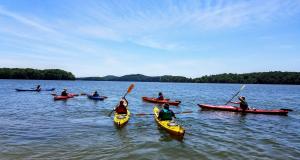
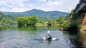
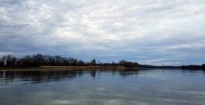
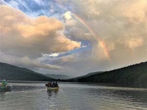
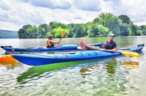
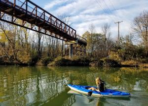
Touring is a form of paddling that’s intended to cover a long distance over a long period of time. Watercrafts will be longer, sleeker and track well on flatwater lakes and rivers as well as on seas and oceans. Touring may involve several hours to multi-day paddling trips with camping along the way. Kayaks are equipped with hatches and bungees to store gear and equipment to stay out for long periods of time.
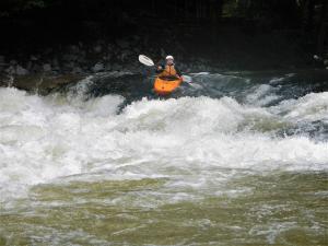
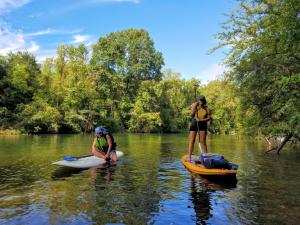
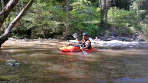
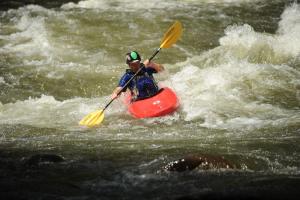
Whitewater Kayaking and Paddle Boarding involves paddling a kayak or a paddle board on a river or creek with rapids. Whitewater kayaking can range from active, moving water, to demanding, extreme whitewater and requires knowledge and skill to navigate and maneuver the craft to avoid dangers/hazards on the river. This type of paddling should never be done alone and prior experience is highly recommended.
Whitewater Rafting is typically done with a commercial rafting company or outfitter that provides equipment, transportation and a trained guide that assists participants in navigating rapids on a whitewater river. Dealing with risk and the need for teamwork is often a part of the experience. Going with a commercial rafting company is highly recommended unless you are trained and skilled in reading whitewater.
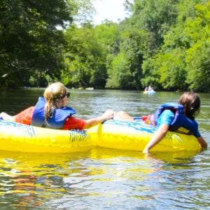
Tubing is the most relaxed form of water recreation in that it requires the least amount of gear or skill. Inflatable tubes are used to float down a Class I-II river or creek.